Surveying & Mapping Drone CT-15 Rotor 6 Stage Fixed Wing Drone
Introduction:
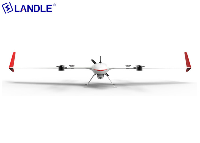
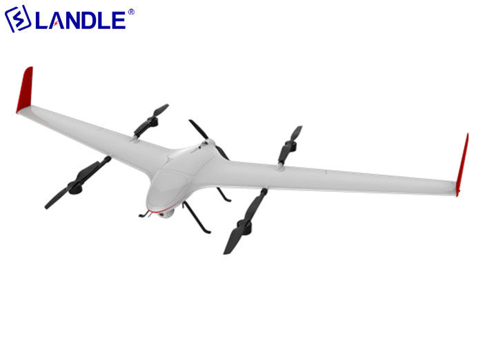
CT-15 fixed-wing unmanned aerial vehicle is a composite wing aircraft with a flying wing layout. It has the advantages of multi-rotor vertical take-off and landing, can take off in situ without a runway, and has long-endurance of fixed wing. The advantages of low noise and gliding are especially suitable for smart cities, police security, road traffic, environmental protection and water conservancy, emergency rescue, oil pipeline inspection, surveying and mapping and other fields.
| Take-off preparation time |
30s |
Long battery life |
150min |
| Aircraft wingspan |
3m |
Recharge mileage |
200km |
| Takeoff weight |
15kg |
Payload |
800g |
| Cruising speed |
900km/h |
Wind resistance |
Rotor 6 stage, fixed wing 7 stage |
Core technical support:
- Core flight control technology
Dual redundant hardware architecture (dual IMU/magnetic compass/GPS)
Automotive-grade high-reliability device with IP67 protection
Open SDK for easy hardware expansion and software development
- Overall pneumatic technology
Aerodynamic shape optimized by CFD digital wind tunnel calculation
Effectively reduce flight resistance and improve flight performance
Design of control law combined with pneumatic data
- Integrated Avionics Technology
Integrated avionics system, effectively improve performance and reduce weight
Including flight control, data link, navigation, 4G and other system modules
- Artificial intelligence technology
Automatic detection and identification of vehicle personnel and defects
Target locking and automatic tracking
Computational recognition based on deep convolutional neural network model
- Security Emergency Technology
Systematic safety emergency measures
With high protection, voltage protection, posture protection
Supports one-click home return, automatic landing and other functions
- Network communication technology
Support one station multi-machine, air relay and mesh networking function
Supports ground-based base station relay transmission communication in ultra-long distance scenarios
Image and data support 30 km transmission distance
Applications:
- 3D Sand Table Modeling of Emergency Disaster
- Aerial emergency surveillance patrol
- Emergency communication network relay
- Power inspection
- Road patrol
- River conservancy inspection

Configuration:
| Frame |
|
1 |
| Motor |
|
5 |
| Flight control |
|
1 |
| remote control |
|
1 |
| Li-battery |
22000mah |
2 |
| Two-axis optical pod |
Visible light 30 times zoom + infrared resolution 640*512 |
1 |
| Communication relay station |
|
1 |
| Dual channel smart charger |
|
1 |
| Aviation aluminum box |
|
1 |
| |
Item no. |
Description |
Unit |
Qty |
| 1 |
CT-15 |
Fixed-wing unmanned aerial vehicle + remote controller |
set |
1 |
| 2 |
F640 |
Two-axis optical pod, Visible light 30 times zoom, infrared resolution 640*512, support GPS information writing |
set |
1 |
| 3 |
DL-30 |
Long-distance 30km communication relay station |
set |
1 |
| 4 |
LB-22000 |
High voltage lithium battery 22000mah*2 |
set |
2 |
| 5 |
SC |
Dual channel smart charger |
set |
1 |
| 6 |
AAB |
Aviation aluminum box |
set |
1 |
| 7 |
F14 |
Two-axis optical pod, 14x zoom 12 million pixels, support GPS information writing |
set |
1 |
| 8 |
DL-18 |
Long-distance 18km communication relay station |
set |
1 |
| 9 |
C5 |
Tilt camera |
set |
1 |
| 10 |
TXGCS |
All-metal dual-screen integrated ground station |
set |
1 |
| 11 |
BSRTK |
Fixed base station for RTK |
set |
1 |
| 12 |
ICC |
Support 4G image return to the command center |
set |
1 |

 Your message must be between 20-3,000 characters!